Striped Whipsnake, Masticophus taeniatus.
Seen in grasslands near the Mineral Mountains.
Saturday, May 23, 2015
Notch Peak, House Range from Confusion Range Camp.
Notch Peak, tallest Peak in the House Range.
Sunset, April 29th.
The Southwest face.
Confusion Range camp with view of Notch Peak.
Sunset, April 29th.
The Southwest face.
Confusion Range camp with view of Notch Peak.
Mineral Mountains, April 27th.
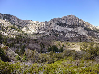
Mineral Mountains on the eastern edge of the West Desert.
Formerly called the Granite Mountains.
Granite Peak.
Formerly called the Granite Mountains.
Granite Peak.
Back in the Wasatch, winter again. April 26.
White Pine Trail, Little Cottonwood Canyon, 4/26.
Ground squirrel out of hibernation.
White Pine Creek, 4/26.
Chokecherries down below the canyon.
Ground squirrel out of hibernation.
White Pine Creek, 4/26.
Chokecherries down below the canyon.
East Canyon Reservoir, Common loon, April 25th.
Common Loon April 25, en route to.....?
Diving.
Osprey on nest, 4/25, Weber River.
Red twig dogwood, Lamb's Canyon.
Diving.
Osprey on nest, 4/25, Weber River.
Red twig dogwood, Lamb's Canyon.
Wednesday, May 6, 2015
Voles and vole damage at Henefer Divide/ East Canyon, April 22.
Sage girdled and killed by voles.
I think I'm seeing a vole population explosion. I've never seen so many in my life as I have this year.
A vole seen in a different area but might be the same kind.
Chamisa bark eaten by voles?
Vole tunnels.
I think I'm seeing a vole population explosion. I've never seen so many in my life as I have this year.
A vole seen in a different area but might be the same kind.
Chamisa bark eaten by voles?
Vole tunnels.
Tuesday, May 5, 2015
Fish Springs NWR, Utah, April 20th.
Yellow-headed blackbird. Xanthocephalus xanthocephalus!
Refuge with Fish Springs Range to the West.
American avocets. Recurvirostra americana.
Willet. Tringa semipalmata.
Refuge with Fish Springs Range to the West.
American avocets. Recurvirostra americana.
Willet. Tringa semipalmata.
Fish Springs NWR, American bittern
American bittern, Botaurus lentiginosus.
I saw more bitterns in one hour (6-7) than I've seen in my whole life! And they were all making their deep pumping " oong- ka- choonk " calls.
Bittern in flight.
Snowy egrets.
White-faced ibis.
I saw more bitterns in one hour (6-7) than I've seen in my whole life! And they were all making their deep pumping " oong- ka- choonk " calls.
Bittern in flight.
Snowy egrets.
White-faced ibis.
Fish Springs NWR, an oasis in the desert. April 20th 2015.
Fish Springs NWR was established in 1959 to provide habitat for migratory bird management within the Pacific Flyway. Approximately 10,000 acres of its 17,992 total acres are wetlands. Refuge waters are supplied by spring flows that arise under artesian pressure and hydrothermal convection along fracture zones in the Great Basin Carbonate Rock and Alluvial Aquifer. Refuge measurements indicate the springs discharge approximately 22,000 – 27,000 acre-feet per year, most of which is recharged from areas outside the Fish Springs Flat.
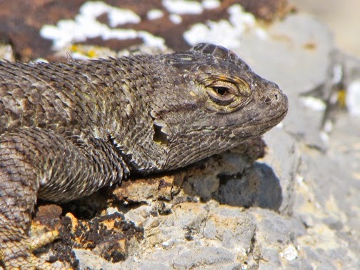
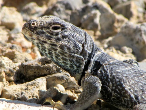
A rogues gallery of West Desert lizards, April 20th.
Desert horned lizard, hiding.
Western fence lizard.
Collared lizard.
Western (Tiger) whiptail, Aspidoscelis tigris.
Western fence lizard.
Collared lizard.
Western (Tiger) whiptail, Aspidoscelis tigris.
Subscribe to:
Comments (Atom)


